Sunday, September 21, 2014

Look what I found on Sparky's Blog!

NEW Palm Single

Since many years, the »Mini Paddle« has proven to be highly reliable portable morse paddle.
Like all Palm paddles the »Palm Single« is also equipped with galvanized gold contacts that ensure maximum contact safety and reliability. For maximum transportation safety, this smallest single lever key in the world can be retracted into it's robust housing, just as known from all Palm Radio keys. The standard housing consists of aluminium, the new ABS housing is optional.
The lever of the »Palm Single« bears a clever mechanism which automatically centers it in the middle position - no adjustments to be made!
Another feature is that you can select either the normal »single paddle mode« or the »sideswiper mode«. The switching between these modes is done directly at the lever by use of the supplied hex key, which is also used for the adjustment of the set screws. The hex key can be stored in the base plate of the key (»QuickMount«) - perfectly placed and always at hand.
Two different set screws per lever side allow precise and individual adjustment of the contact gap and the spring pressure.

The characteristics of the »Palm Single« at a glance:

  • Hard, defined stop of the paddle lever.
  • Automatic centering of the lever- no manual adjustments required.
  • Paddle pressure per side individually adjustable from approximately 2 to 40grams.
  • Galvanized, gold-platedcontacts.
  • Easily selectable between single paddle and side swiper (CootieKey) mode.
  • Low mass: paddle lever only 6 grams
    complete key 48g (aluminum housing) or 30g (ABS housing).
  • Paddle lever can be retracted for transport and is therefore best protected.
  • Smallest single lever key in the world: 25 x 25 x 79 mm = 1 x 1 x 3.1 inch.
  • Housing: standard is the aluminum housing, ABS housing optional.
  • Supplied: Manual, QuickMount (universal mountingplate with magnets) and Palm Radio connection cable (3-pin connector with plastic housing).

Palm Single


Innards of the PS
 

Palm Single Instructions


Monday, September 15, 2014

Amateur Radio in Australia (VKFAQ): What is SOTA?

What is “Summits On The Air” (SOTA)?

The SOTA programme is an amateur radio awards programme, not a contest. It is about making radio contacts from selected mountain summits, or making contacts with operators on those summits.  It was first launched in the UK in about 2002.
SOTA operates under general rules published at http://sota.org.uk in conjunction with specific rules in the Association Reference Manual (ARM) for each Association, where regions, height bands for scoring, winter bonus details and summit lists are published.
The individual ARM documents do not repeat the basic rules of the programme so it is worth reading the documents:
  • General Rules – English version (or other language if you prefer)
  • Guidelines for Activators
  • Guide for Joining in
  • SOTA Leaflet – worth printing a few for sharing at your club

What is SOTA in Australia?

In Australia there is an Association for each call area vk1-vk9. However these associations are unincorporated. They are informal associations you join virtually if you operate.
Each Association has an Association Manager, the name of whom is in each ARM. Within each region of each association there is a provision for a region manager.

What web resources are available?

The programme operates with a great deal of support from the SOTA organisation in the UK, a voluntary amateur group. They run the following websites:
  • Sota.org.uk ­ general rules of the programme
  • Sotadata.org.uk - ­ online database containing association and summit details, summit search, logs of operators, honour rolls, awards for activators and chasers.
  • Sotawatch.org ­ - an online logger and alert manager allowing you to see what operations are planned and what signals have been reported on the air. An online forum like the SOTA_Australia (Yahoo) mailing group is also conducted on that website. You can optionally receive forum items via email - see options in your user profile.
Maps are also linked from sotawatch and sotadata. Here you can view details of specific summits, maps showing all the summits in a region or in an association, or download files for use your mapping software or GPS. These online maps are based on Google maps and many of the same facilities are available for zooming, marking points etc. Some use OziExplorer software to view their planned summits and can export waypoint files to their GPS from OziExplorer, or export KML/KMZ files suitable for Google Earth and Google Maps.

Can I access SOTA sites via Apps on my smartphone?

  • SOTA GOAT for Iphone (from Itunes App Store). Has a summit list (updatable on line) and can separately show spots and alerts. Can be configured to notify you of each new spot on chosen modes and in your preferred time ranges, with a goat bleat.
  • Rucksack Radio Tool for Android phones (from the developer at http://www.dl1dlf.de/rucksack_radio_tool). Announces new Spots with a voice announcement stating the country and band of the spot.
  • There are other useful software tools for your internet equipped phone and for an SMS-only phone. 

What local info and services are available?

In Australia the Yahoo Mailing Group at http://au.groups.yahoo.com/group/SOTA_Australia/ provides these services:
  • A mailing list (SOTA_Australia) for distribution of emails to all subscribers. Self managed subscriptions.
  • File storage/web site at yahoo groups where you can find photos, GPS tracks/waypoints for specific summits, notes and helpful documents
  • Databases showing the status of each state/association along the route to getting that state going on the SOTA programme. As of Sept 2013, VK6, VK7 and VK8 were not registered and VK4 was partially registered with four regions in the most populated areas.
  • Links to various websites including the above and the websites/blogs maintained by various active SOTA operators.
Several associations have local mailing groups on yahoo groups for local/domestic discussion and social event scheduling. These were set up to limit the amount of irrelevant material (eg. about the location or other details for a social event) on the national mailing group.

What do I need to read before going on the air and making contacts?

Ideally, look at all the above. Read the websites, the documents, look at the maps. Work out what’s near you or if you are in a state that’s not registered yet, find out who is working on your state and how to contact them. There are names and callsigns listed in the "database" section of the Yahoo group for each state.

What next? How do I join in?

To participate as a chaser:

  • Listen for activators on the air at the times advertised as Alerts on SOTAWATCH.ORG or notified on the SOTA_Australia mailing list (not all are notified there).
    Make contacts with the activators and note the code for the summit they are operating from. Record the summit code in your log.
  • You earn points for each separate summit you work in each UTC day.  For this reason, you will find some activators work stations once before 0000 UTC and once after that time.  This is no advantage for the activator but it does help chasers earn points
  • Go to SOTADATA.ORG.UK and register a user id (your callsign should be ok) and password. You’ll receive a confirmation email. Record your password somewhere safe. This user id links your callsign to your log of contacts both as a chaser and as an activator.
  • Record your contacts in the chaser log to start your award points
  • Repeat until you reach the points level needed for each award level, eg. 100 chaser points, 250 etc.
  • On reaching 1000 chaser points (typically 250 contacts at about 4 points each, on average) you can apply for the Shack Sloth Award.  Details on the sota.org.uk site.  There are higher levels of awards with no limit.

To participate as an activator:

  • Select a summit you want to operate from
  • Work out how you will access that summit eg. how far can you drive up the summit
  • Prepare your equipment, antenna, power source, backpack
  • On the day of your activation, take a buddy to walk with and join in the fun. Some activators walk with their family (spouse and/or kids) and others jointly activate summits with friends from their radio club. Others take their dog or their goat (see WG0AT’s videos on Youtube)
  • Let others know what you are planning
  • Post an Alert to SOTAWATCH several days before your activation
  • Post some comments about it on the Yahoo mailing group
  • Take a note of your intended summit code. Write it into your portable log at home
  • Advise your family where you are going and how to contact you if you are running late. Your family’s cooperation and assistance is vital and could save your life in the event of an accident or injury.

On the summit:

  • Ensure your “final approach to the summit” is by non-motorised means, unless you normally use a motorised wheelchair, which is permitted. Operators who have impaired mobility are encouraged to participate in SOTA.
  • Your station including radio, antenna and power source must be independent of any vehicle. The test for this is to remove the vehicle - it should not affect your ability to operate the radio and make contacts, and should also not affect any shelter you use to operate from.
  • You don't need to go solo - joint activations with one or more others are quite legitimate and encouraged.
  • Either SPOT yourself or ask one of your contacts to SPOT you on SOTAWATCH
  • Set up your equipment, work the contacts and enjoy being the dxpedition everyone wants to work
  • Log your contacts
  • Once you have worked 4 stations you have “qualified” the summit and you have earned your activation points.  You can get those points for each summit once per calendar year.
  • For some summits you can also earn winter bonus points for activating them in the winter months. Some regions have no winter bonus points and some have different winter periods. The bonus applies only to activators. The chasers are at home in a warm shack!

Back at home:

  • Upload your contacts to SOTADATA
  • Plan your next activation and probably how you will lighten your back pack but take more food and water
  • Have fun and stay safe.

What if my state is listed as still being surveyed?

Anyone can help with the surveying. Contact the nominated person for your state and ask what you can do to help. It is all done on computers at home, no site visits are required.
In the meantime, you can operate as a chaser of SOTA ops anywhere in the world and you can activate any summits in the world. Start with those in other states.

Can anyone make contacts or do you have to be registered?

There is no need to register. You can activate summits and you can make contacts as a chaser, entirely without registering anywhere. It is amateur radio and open to all. However if you want your contacts to earn points towards the awards you need to upload the contacts at SOTADATA and to do that you need to register a user id, your callsign name and email address. A confirmation email is issued to you to confirm that the email address you quoted is a valid one.

Are there fixed frequencies for SOTA operation?

No. A starting frequency of 7.090 has been common in south east Australia on 40m but that has simply been a convention. You operate within the terms of your licence, using the bands and modes you are licenced for and are keen to use. There is some PSK31 operation elsewhere but in Australia most operation has been SSB and CW on HF, FM and SSB on VHF.  
With additional states coming “on line” in 2013, more interest is being shown in higher frequencies that will allow longer distance QRP contacts.  30m, 20m and 15m have been used.  In summer 10m is likely to be very active when conditions are right. 6m is also likely to be used during Es season.

Are there fixed times or dates for SOTA operation?

No. The most popular days in southeast Australia are weekends with slightly more activity on Sundays. There is some weekday activity notified on sotawatch.

How far up the mountain do I have to climb before I can consider myself on the summit?

You may operate anywhere within 25m (vertically) of the peak. This area of the peak is defined as the activation zone.

What is the minimum distance I have to walk?

  • There is no fixed minimum distance. It is recognised that summits vary in their access, difficulty, slope, terrain, foliage etc. You may wish to operate from the top of the summit but it may be inaccessible to a walker. The amount of horizontal distance required depends on the gradient/slope and where you wish to operate within the activation zone. eg. a 1/10 slope means it would be 250m from the border of the activation zone to the very top of the summit.
  • Most activators like to reach the top of the mountain and operate as close as possible to it. Conquering the mountain is an achievement. Operating from the top is too.
  • You need to enter the activation zone before your operation using non-motorised means, carrying your equipment, antenna, food, water, tent or other protection etc.
  • You may not operate close enough to your vehicle that it becomes any part of your station, ie. supporting antennas, supporting weather protection, providing a wind break or providing power for your equipment. You must be independent of your vehicle, so that if your walking partner drove it away 100m it would not affect your operation.
  • It is permitted to drive your vehicle into the activation zone (eg. to park it safely) but if you do that, you must leave the activation zone with your equipment and re-enter on foot. That becomes what SOTA rules refer to as your "final entry" to the activation zone, ie the last entry you made before operating on the air.
  • After your radio operation is completed you have satisfied all the rules and you can just walk to your car and put your equipment into it whether it is parked near the summit or not.
  • Some have asked whether it would be permissible to park their vehicle 1m outside the activation zone and then operate 1m within the activation zone, reducing the walk to 2m. Technically yes. But in that case you will be likely to infringe the rule about not using your vehicle as part of your station. You would also have to walk more than 2 metres simply to erect almost any antenna.
  • In your interpretation of the rules, you are responsible for observing the rules to your satisfaction. If you bend the rules, you are not cheating anyone but yourself. You must consider whether other activators observing your activation would consider it valid. Assume others are watching and are prepared to protest your activation especially if you are a high scorer. Play fair.

Why is my local hill not listed? Can it be added in the next update?

There are two possible reasons.
  1. It may not have 150m prominence as required by SOTA guidelines. Yes, SOTA does have rules, it is not simply "go portable on a hill", it is more specific than that. Many people will be disappointed that their local dog walking hill won't qualify. Sorry but for the award to mean something, not every hill gets included. Without a basic prominence requirement there could be a million hills in Australia alone. That would subtract a lot from the uniqueness and value of the summits.
  2. It may not be listed because it was missed in the initial survey work that identified complying summits. If we identify it later, or someone lets the association manager know the details, including lat/long/altitude (m) and evidence that it has the prominence to qualify as a SOTA summit, it will submitted to the SOTA management team for approval and if approved it will be added in the next annual update.

What is the basis of the points allocated to summits?

Each ARM defines the height ranges for each point value. Height above seal level is the basis of the points table and is the only factor once the summit has proven to have at least 150m prominence.

Why are some summits with road access rated as many points as those without?

That's the luck of the game. In all associations/countries/call areas there is a mix of easy access, high points, difficult access, low points. Take the good with the bad.

How often can I activate a summit?

As often as you like. But you will only get activation points for that summit once each calendar (UTC) year. So on 1st January get up there early, activate before 0000 UTC and again afterwards. Points earned for both years.

I hear stations having second contacts. Are points scored for both contacts?

The activator only gets the points once per calendar year. But chasers can get the points once per day for each summit.

What about dual or multiple operators at a summit? How does that work?

Each operator can run their own log. Once each of them have made contacts with 4 different stations, they have qualified the summit and will get their summit points.
For chasers, there is no value in making contact with each of the operators, once you have made one valid contact with that summit on the current (UTC) day. But after 0000 UTC chasers can work the summit again for award points. To do that, the activator has to be willing to stay long enough to work everyone again. They have no obligation to do so though.

Some activators seem to want very short contacts. I prefer a ragchew type of contact? Can I ragchew with an activator?

They are limited by the capacity of their battery power, how much food and water they carry, the weather conditions and how far they have to walk down to their car or transport. They have the right to request a short qso, even as short as signal reports and summit code. But most activators are happy to chat if they have enough power, the weather is good and there is no queue of chasers wanting contacts. Ask them if they saw any snakes on the walk and whether they have a hat and sunscreen. ;)

Only some of my local summits have public access and a road up to the top. Other activators have many. Is there a handicap system to compensate me?

No.

How can I find out who owns a summit so I can get permission to access it?

Ask around. The local council could provide info. Residents in the area either know, or know who to ask. Be diplomatic and respect privacy. SOTA and ham radio generally does not authorise you to enter private property in pursuit of points for an award. SOTA rules state that if you activate a summit without permission from the owner, the points will not count. In Australia some roads and ranges are closed during periods of total fire bans and in winter conditions when snow and ice makes roads dangerous. If a summit is in a "entry prohibited" area you will not get points for activating it.

I'm having a lot of fun with SOTA. Are there handouts or other materials I can use for a presentation to my club?

Your state association manager or your regional manager may have materials or may be willing to present to your club about SOTA. Ask on the SOTA_Australia mailing list. Find the contact details from the ARM.
There is a SOTA leaflet available on the SOTA.ORG.UK website. It prints as an A4 double sided sheet and is intended to be folded into a 3 leaf brochure. You can download the PDF, print a few copies and distribute them to enquirers.

http://vkfaq.ampr.org/opersota.php

Friday, September 12, 2014

Potent Solar Flare — Auroras Tonight?

By: Kelly Beatty

On Wednesday afternoon, a powerful X-class flare ripped through the Sun's lower atmosphere and sent a blast wave directly toward Earth that should arrive Friday and produce moderate-to-strong auroras over the weekend.
Solar flare on September 14, 2014
The Sun erupted with an X-class solar flare on September 10, 2014, as captured by an X-ray imager aboard NASA's Solar Dynamics Explorer. (Blue color is artificial.)
NASA / Goddard Space Flight Center
Solar physicists believe that the Sun's current 11-year-long activity cycle peaked weakly last year and has already started to decline. But today our star sent a powerful reminder that, paraphrasing Monty Python, "I'm not dead yet!"
On Wednesday afternoon, the Sun erupted with a powerful flare that peaked at 1:48 p.m. Eastern Daylight Time. From its perspective in space, NASA's Solar Dynamics Observatory captured the titanic explosion, which covered an area several times larger than Earth.
SDO time-lapse images, recording X-ray emission at 193 angstroms from highly ionized iron atoms, show the blast wave rippling across the entire solar disk:
According to NOAA's Space Weather Prediction Center (SWPC), the flare was an X-class event — the most powerful — and it unleashed a torrent of relativistic particles and X-rays that swept over Earth minutes later.
Meanwhile, observer Steven Souza (Williams College) happened to witness the flare while viewing the Sun through a telescope equipped with a hydrogen-alpha filter. "He called me a little after 1:30 to say I should hurry upstairs," recalls his colleague, solar expert Jay Pasachoff. "Looking through the telescope, I could see the normal red disk of the Sun, but in its midst I saw a tremendously bright 'S' shape. It was on the left side of a dark spot, presumably the underlying sunspot, and there was an arc more-or-less completing a circle on the right side. The S-shape reminded me of the 'sigmoids' that my Caltech post-doc advisor, Harold Zirin, had proposed as a sign of flare-worthy active regions."
A half hour later, the bright regions were still visible but less prominent. It was, Pasachoff notes, "the brightest H-alpha flare I have ever seen (in contrast with the rest of the solar disk)."
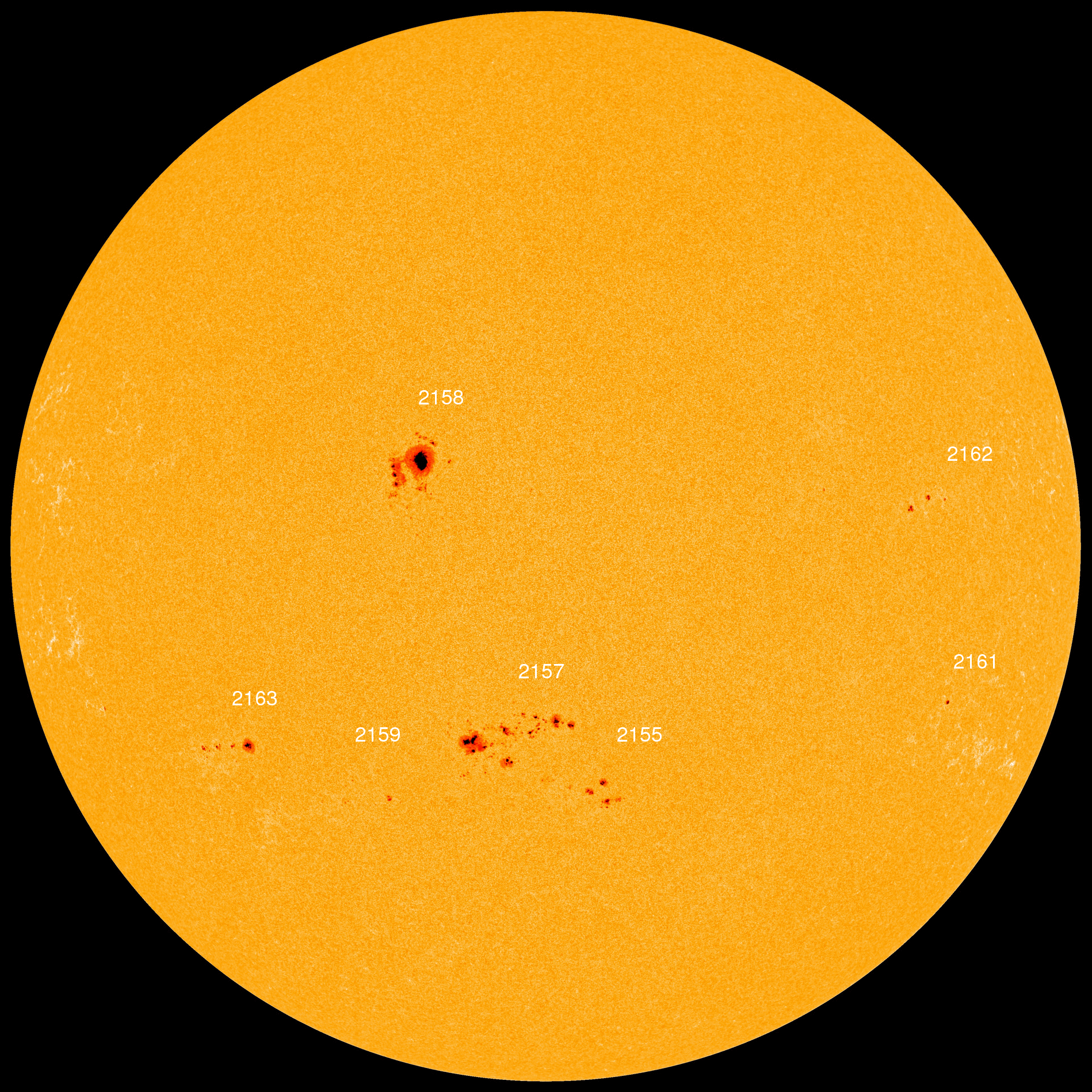
Sun_AR2158
Solar physicists have been monitoring Active Region 2158, and its potential for dramatic flares, ever since it rotated into view 5 days ago.
NASA / Goddard Space Flight Center
The X-1.6 eruption came from a sunspot group known as Active Region 2158, situated very near the center of the solar disk. "It's pretty clear there was a large coronal wave," notes C. Alex Young, an associate director in the Heliophysics Science Division at NASA's Goddard Space Flight Center, with a coronal mass ejection (CME) directed squarely at Earth.
Based on the initial SDO imagery, Young estimated that the CME could have a velocity of up to 2,000 miles (3,000 km) per second, very fast as solar storms go. Later imagery from the Solar and Heliospheric Observatory (SOHO) showed the expanding blast wave escaping as a rapidly expanding halo around the Sun's entire circumference — a clear indication that it's headed our way.
Later, however, Young sent Sky & Telescope an update: the CME's initial velocity was less than initially thought, about 875 miles (1,400 km) per second.

Timetable for Auroras

Therefore, the shock front now crossing interplanetary space should reach Earth on Friday morning. SWPC forecasters are predicting a moderate G2 geomagnetic storm on Friday and more robust G3 levels through Saturday. These could trigger displays of auroras over locations roughly northward of latitude 45° north (Oregon, Illinois, New England, and northern Europe).
Although the "northern lights" can appear anywhere in the sky, would-be aurora watchers should look first toward north. Most displays appear as shimmering greenish curtains of light suspended in the sky. Stronger auroras can appear tinged with blue or red.
AR 2158 was also responsible for a lower-intensity eruption yesterday. Although not headed directly at Earth, that predecessor could create a partial clearing in the interplanetary medium that would allow today's blast to reach us sooner that it otherwise would. The likely merger of these two shock fronts is the reason for the potentially stronger geomagnetic disturbance on Saturday.
Solar flares occur in areas of concentrated magnetic fields in and above active regions. Contorted bundles of field lines can reconnect suddenly and violently, releasing vast amounts of stored energy in an abrupt "explosion" that propels blobs of the solar atmosphere outward. A powerful "super storm" in July 2012, perhaps the most energetic in 150 years, directed a perilously strong CME into space that fortunately missed Earth.

Could Earth ever fall victim to a "solar superstorm"? Gets the odds of that happening — and the consequences if it does — in the February 2011 issue of Sky & Telescope.
- See more at: http://www.skyandtelescope.com/astronomy-news/observing-news/powerful-solar-flare-091020143/#sthash.l1D5ZZXO.dpuf

'Extreme' Sun Storm Heading for Earth, Scientists Say

Published: Sep 10, 2014, 8:13 PM EDT weather.com
An extreme solar flare is heading toward Earth – one the size of which scientists say they haven't seen coming from the middle of the sun in years. The solar storm could interfere with power grids, satellites and radio transmissions, and even though these events are common and don't directly harm humans, this particular flare is disconcerting because of its strength and location on the sun, said Tom Berger, director of the Space Weather Prediction Center in Boulder, Colorado.
"There's been a giant magnetic explosion on the sun," Berger said. "Because it's pointed right at us, we'll at least catch some of the cloud" of highly energized and magnetized plasma that can disrupt Earth's magnetic sphere, which sometimes leads to temporary power grid problems.
Forecasters don't yet know when Wednesday's solar storm will arrive here and which part of the planet will be facing the sun and bear the brunt of the effects. It could arrive as early as Thursday morning or may take a few days.
Berger said scientists will have a better idea after they get more satellite data. The first part of the storm, which arrives in only a few minutes, has already affected radio transmissions. It can also damage satellites.
The flare is considered "extreme" on forecasters' scale, but just barely so, Berger said.
On the plus side, sun flares expand the colorful northern lights so people farther south can see them.
Information from the Associated Press was used in this report.
MORE ON WEATHER.COM: Images of the Sun from NASA


This close-up look at an active region taken on July 9, 2010, shows a hotbed of magnetic activity, including a small solar flare bursting out into space. (NASA Solar Dynamics Laboratory)

Monday, August 25, 2014

New Summit Activation, 25 August 2014, W7M/GA-114 Summit #7154

Summit Activity

Total Activations: 1

  • KG7KGL on 25 Aug 2014
First Activated by:
  • KG7KGL on 25 Aug 2014

      4 QSOs on these bands:
       2m4100%

      Displaying 0825141258a.jpg

      This week Colton and I headed to a summit east of Stevensville, Montana called #7154. All that number means it that the mountain is 7154' ASL. We had our 4 contacts in record time (less than 15 minutes) and I don't know if that was because of my great antenna building, Colton's new braces propagating the signal and or lots of people listening to their radios today. Either way everything went really well. 
      Thanks to all my chasers!

      73

      KG7KGL

      Sunday, August 24, 2014

      North America SOTA Activity Weekend, Setptember 13-14

      North America SOTA Activity Weekend 2014, September 13ths and 14th, is a casual event involving tiny battery-powered radios on mountain summits.  It i s not a contest but is intended to introduce "Summits on the Air" to newcomers with home stations who try to work summit operators during one or two days. There are no rules regarding power levels, modes or number of bands worked, but please be courteous when more than one station is trying to talk to a SOTA operator on a summit.  The SOTA operators have just climbed mountains as high as 14,000 feet; they use low power; and they don't receive on split frequencies.
       
      Check SOTAWATCH.org to spot who is on which mountain.  Summits are numbered, and you can hover your cursor over the number to see the name and point value for each summit.  Expect the website to show activity near 7.032, 7.185, 10.110, 14.342, 18.095, 18.155, 21.350, 24.905, 24.955, 28.420, 146.52, 446.00, and 61 Khz up from the bottom of 20, 15, and 10 meters CW.  Participants are invited to collect points toward certificates and trophies offered by the twelve-year-old international SOTA group (SOTA.org.UK).  As we learned in past years, this is a barrel of fun for both hill climbers and home operators.  See you then. 

      Summit W7M/GA-114

      I don't know much about this summit, besides it is east of Stevensville about ten miles as the crow flies and it is 7,154' ASL.
      The summit is all timbered so I want to see how my new antenna works. The new antenna worked great on Trapper Peak, so now we need to test it below the treeline.
      I plan on being on station starting at 12 noon, Monday, August 25, 2014. My primary frequency is 146.520-fm, and my two alternate frequencies are 146.550-fm and 146.580-fm.

      If you would like to become a chaser or activator please go to:
      http://www.sota.org.uk/JoiningIn

      After each summit activation I log my contacts, so if you are one of my contacts you already have points as a SOTA chaser.

      73

      KG7KG:L


      Summit #7154

      KG7KGL on W7M/GA-114 - [edit]146.520-fm,146.550-fm,146.580-fm
      Easier hike this week. Go to: http://mtmotorstables.blogspot (Posted by KG7KGL)

      Monday, August 18, 2014

      RADIO BUSINESS:BAOFENG CHANGES NAME TO POFUNG

      Radio supplier Baofeng has changed its product distribution name to Pofung for all sales outside China.  In an announcement on its website the company says that it feels it's time to adapt its brand to the global stage.  It notes that the current name Baofeng is a literal translation of it's Chinese character name, and as such it may be difficult for a hobbyist elsewhere in the world to pronounce.  The company say that its new product name of Pofung is easier to pronounce and more friendly to its customers, while maintaining the phonetic symbolism of its brand.  The company's official web domain www.baofengradio.com will remain unchanged.  (Baofeng)

      Source: Amateur Radio Newsline

      Sunday, August 17, 2014

      New Summit Activation, 17 August 2014, W7M/RC-001 Trapper Peak

      Summit Activity

      Total Activations: 1

      • KG7KGL on 17 Aug 2014
      First Activated by:
      • KG7KGL on 17 Aug 2014
      Activated by You on:
        17 Aug 2014

        4 QSOs on these bands:
         2m4100%

        Well we did it. Trapper Peak was activated today. Thank you to everyone who answered my CQ. It was a good hike; 4.2 miles one way and 3,800 feet of altitude one way. Colton and I wanted to do this hike for awhile so all we can say now is: "Mission Accomplished."

        Displaying 0817141115a.jpg

        73

        KG7KGL


        Saturday, August 16, 2014

        Trapper Peak, 10,157 feet

        Sunday, August 17, 2014 my son Colton and I are going to climb Trapper Peak and activate the summit.


        We are hoping to be on the trail at 6:00 am, and get to the top NLT 9:00 am. We are going up early because the weather forecast is calling for thunderstorms in the afternoon.


        So we want to be off the mountain when all that takes place.

        Colton and I have been talking about climbing Trapper for many years and tomorrow is the day.
        Annie is going to stay home and sleep in. It is a dog's life eat and sleep.

        For all you Chasers out there we will be using the following frequenicies:
        146.520
        146.550
        146.580

        I hope that my new antennas work. I am a little concerned about static electricity building up, but I guess we'll see what happens.


        Anyway, I'd better get to bed; 4:00 am will come really fast.

        73

        KG7KGL

        Wednesday, August 13, 2014

        You can tune a antenna but you can't tune a fish!

        Thanks to Jeff, BJ, Jim and Bob for your advice, help and testing equipment with my new antenna. Here is a picture of my newest creation:
        Displaying 0812142043.jpg
        Bob says it sounded great when we talked last night, so I can't wait to get it on top of St. Mary's Peak tomorrow. It folds up nicely in my day pack so hopefully my antenna issues are over.
        After I got done talking to Bob, I decided to go in the garage and find some items to make into an day pack pocket antenna.
        Here is what I came out of the garage with:
        1) a bamboo stick
        2) some speaker wire
        3) electrical tape
        4) a 6" piece of coax with a So-239
        This is what I built in 5 minutes:
        Displaying 0812142101d.jpg
        I know it doesn't look like much but it made commo. Bob said it sounded good as well. I read somewhere that "all antennas want to work." Well, that may true; I guess we'll find out tomorrow.

        73

        KG7KGL

        Monday, August 11, 2014

        Change of Plans!!!

        Window Sticker

        As so often the case, plans and dates sometimes change. That being said the 2nd attempt at St. Mary's Peak has been moved back to Thursday, August 14, 2014. I hope to be on the summit by 1000 hrs local time and 1600 hrs UTC.
        I cannot wait to try out the two new antennas I have built. So far the antenna situation has been the weakest link in my expeditions. So Thursday we'll see how my new creations work.
        We'll be on the 2 meter band at the following frequencies:
        146.520 - fm
        146.550 - fm
        147.550 - fm

        73

        KG7KGL

        Sunday, August 10, 2014

        St. Mary's Peak Video


        2nd Attempt at St. Mary's Peak!


        Annie and I climbed St. Mary's Peak back on July 22, but I only made two contacts. So the plan is to climb St. Mary's Peak this week and try out the new antenna. I am going to take another antenna to test out as well. If everything goes as planned I will make four contacts (hopefully more) and we will set our sights on Trapper Peak the following week. 

        We'll be on the 2 meter band at the following frequencies:
        146.520 - fm
        146.550 - fm
        147.550 - fm

        If you want to become a activator or chaser with the "Summits On The Air" or SOTA here is the website to register:

        http://www.sota.org.uk/JoiningIn

        Until next time,

        73

        KG7KGL

        Wednesday, August 6, 2014

        New Summit Activation, 5 August 2014 - W7M/RC-017 Sweeney Peak

        I need to say this up front, this activation Kicked My Butt! I think the dog was pretty tired as well.
        Displaying 0805141354b.jpg

        Tuesday the 5th of August, my trusty companion (Annie) and I ventured up Sweeney Peak. Sweeney Peak's Summits On The Air (SOTA) designation is W7M/RC-017. The peak is just west of Florence, Montana. It is between Lolo Peak to the north...
        Displaying 0805141129.jpg

        and St. Joseph Peak to the south.
        Displaying 0805141126.jpg

        It is a 4.5 mile hike from the trail head and you gain 3,415 feet in elevation to a summit elevation of 9,161 feet. Hikes like this take me awhile to accomplish. On top of that I have never been to this summit so I probably didn't take the best route. Oh well, we made it to the top and then the fun began.
        I was still having problems with my home brew antenna. The basic configuration is a ground plane. If you read any instructions about this antenna it says:

        The vertical radiator (A) should be soldered to the center connector of the SO239.

        Well after hiking a few summits the vertical radiator looked like it was soldered, but on very close (get out the reading glasses) inspection it was not. Oh great! After I dragging my dog and myself all the way up this mountain now I find out that my antenna is broke.
        So out came the knife, the electrical tape, zip ties, a empty box of raisins and I don't know all what else and I went to work trying to build something like an antenna that would work. Now everything I tried was for memory and they look nothing like the real thing, but they did get the job done.
        So first I tried something that resembled a dipole. OK, I got two contacts with that. Then I tried something like a long wire with all the 19.2 inch pieces of copper wire I had. With this monstrosity I got two more contacts. The last thing I tried was what I call the "On Top of Sweeney Peak Bazooka." Kids don't try this one at home, but I was able to make one more contact, just as we heard some thunder off to the north. At 9,000 feet on a bare summit thunder is usually my cue to leave and we did.
        All in all this was a great experience for me as a amateur radio guy, but it really did kick my butt. I need to get rested up because next Tuesday we are heading up Trapper Peak. Wish us luck.

        73
        KG7KGL

        Monday, August 4, 2014

        How do you charge your radio's battery on a SOTA expedition?

        This Gadget Can Charge Your Phone in the Middle of the Woods Using Only Water and a Flame

        by Elizabeth Kreft

        In the woods with a dead cellphone? You aren’t up the creek without a paddle if you have this nifty gadget.
        BioLite — a company that uses thermoelectric technology to build advanced stoves for outdoor adventures and emergency preparedness scenarios — designed a kettle that can charge your phone with just some water and a flame.
        BioLite-KettleCharge-01
        The KettleCharge just needs water and a flame to provide electricity. (Image source: BioLite)
        The kettle has a thermoelectric generator built into its base and uses a difference in temperature to produce electricity: The water acts as the cool side of the equation and the flame is the hot. As the water begins to boil, electricity is produced and sent to the power handle, providing 10 watts of usable power.
        That’s enough electricity to charge a phone, or even a tablet, as fast as a wall outlet could.
        The KettleCharge team says they are eager to provide solutions that not only give users the ability to stay connected while camping, but more importantly to provide access to perhaps lifesaving electronics while off the grid.
        “It works on a wide range of stoves and serves as a perfect personal-scale generator for your everyday devices,” BioLite says.
        The thermoelectric generator used in all of BioLite’s products was invented by Alexander Drummond and Jonathan Cedar; according to their site, the stove technology “was inspired by a philosophy of applying efficient design to real-world problems.”
        In the larger stove designs, a fan harnesses the electricity generated and burns the flame more efficiently, but in the KettleCharge, the fan is replaced by a USB charger.
        The gadget is available for pre-order now for just under $150; the kit comes with a custom USB extender in case the user wants to charge a phone in real-time, so that cords don’t won’t melt near the flames.
        Check out the technology below:

        Amateur Radio Emergency Go Kits

        by Amateur Radio Online

        Amateur Radio Operators involved with the Radio Amateur Civil Emergency Service; “RACES”, The Amateur Radio Emergency Service; “ARES” or even the SKYWARN system are prepared to respond in emergency situations to provide radio communications in the event of primary communication failure, like the 911 emergency system, or to provide secondary communications, non life threatening but vital information, during an emergency situation.
        Amateur Radio operators that are involved with these emergency organizations keep what they call a “GO BAG” at the ready. When an emergency event occurs these “Go Bags” are ready for deployment assuring that the Amateur Radio operator has the supplies and equipment they will need to deploy quickly to their emergency posts.
        The contents of a “Go Kit” will vary depending on the individual Ham Operator. They range from the simplistic to being in some cases exotic! Some Ham Operators really go to the extreme and are equipped for almost any situation you could possibly think of.
        When you plan out your “Go Kit” there are several basic things you should take into account. One of the first things that come to mind is where you will be most likely deployed. Do you live in an urban area or a rural area? A “Go Kit” designed for a rural environment may have camping equipment as one of its primary components, for example a “Go Kit” for rural deployment might have fire starting supplies compared to its urban counterpart.
        In any case you should have at the least:
        • A 2 meter or better yet a dual or tri band Hand Held (HT) radio
        • An antenna other than the basic HT antenna that came with your radio. Such as a J-Pole or other antenna with a bit more gain to it.
        • Extra batteries or an auxiliary power source.
        • Writing materials: Paper, notebook, pens, pencils
        • Personal comfort and hygiene supplies. (TOILOT PAPER!)
        • Some sort of Food Bars and a water bottle that can be filled before you deploy.
        • About 20 dollars emergency cash.

        Many Amateur Radio Operators will break their kit up into 3 levels of deployment.
        • The Day Kit - For short term deployment and emergency drills. Small fanny pack, light weight.
        • The Supplemental Kit - Taken when you will be deployed 24 hours or better. Backpack or other suitable carrying bag.
        • Disaster kit – For when deployment will be for extended amounts of time. Large duffel bag or back pack.
        Keep in mind when you design your “Go Kit” that it is of the utmost importance that you will be totally self sufficient during an emergency situation.  You should not become a liability to others around you.
        The following suggested lists are from RACES.
        DAY KIT
        • Dual-band HT in padded belt case.
        • Copy of current FCC Operating License.
        • "Tiger tail" (enhances transmit and receive of typical "rubber duck" by 3 db).
        • Extra high-capacity (1000 man) NiCad, or backup AA battery case for HT.
        • DC adapter & cigarette plug cord for HT
        • Two extra 2A fuses, for HT cord.
        • Earphone and/or speaker mike
        • Spartan pattern Swiss Army pocket knife
        • Leatherman multi-purpose tool
        • Mini-Mag-Lite, extra bulb and spare AAs
        • Pencil and pocket notepad
        • Emergency gas / phone money ($10 bill, + four quarters and five dimes in pill box).
        • SO-239 to male-BNC adapter to fit HT to mobile antenna coax and female BNC to SO-239 to fit HT gain antenna to jumper.
        • 6 ft. RG8-X jumper w/BHC male and female connectors to extend HT antenna with suction cups or auto window clip.
        • Spare eye glasses of current prescription.
        • Band aids, moist towelettes and sunscreen
        • Pocket sewing kit, matches
        • Small pocket compass
        • Operating reference card for HT
        • ARES phone and frequency reference card
        The Supplemental Kit – Backup Bag
        • Neck-lanyard pocket with spare car keys, $20 emergency cash, credit card, long-distance calling card and ARES photo ID.
        • Second, "backup / loaner" 2-meter HT. (battery packs and accessories should interchange with the dual-bander)
        • Spare NiCad and AA-battery pack, ear phone and speaker-mike for second HT
        • Operating manuals for HT''s.
        • Fused DC adapter cords with Molex connectors for brick amplifier and HTs
        • Extra 10'' AWG 10 gage twin lead extension cord, with battery clips, in-line fuses and Molex connectors to power brick amp or HT.
        • Compact, rugged, 25-40w 2 meter or dual-band brick amplifier. - See note at right>>.
        • Gain antennas for both HTs: (telescoping half-wave Larsen and flexible dual-band Comet CH-72, 1/4-wave VHF, 5/8-wave UHF).
        • HT NiCad and 12V gel cell wall chargers.
        • Four NP2-12 gel cel1 batteries to power small brick amp at 10w @ 25% duty cycle / 8 hrs.
        • Two refills of AA Alkaline batteries for HT.
        • RG8-X jumpers with soldered PL-259s, two 3 ft., one, 6 ft., one 10 ft. and one 25 ft. with double-female connectors to combine all.
        • BNC-male+BNC female to SO-239;
        • BNC-male+BNC female to PL-259;
        • NMO to SO-239 adapters.
        • Cable ties, large and small, 6 each
        • Lensatic compass, 7.5min. series area topo.
        • Two sharpened pencils, pencil sharpener, gum eraser, note pad, permanent marker.
        • ARES Field Resource Manual
        • Compact, rugged, flashlight (Pelican Stealthlite), with extra bulb and AA batteries
        • Two sets of spare fuses (2A, 10A, 15A) for HT cords, mobile radio or brick amplifier.
        • Comfort, safety and basic first aid items: sunglasses, matches, tissues, toothbrush, sun block, sewing kit, insect repellent, tweezers, band-aids, adhesive tape, gauze pads, wound cleaning wipes, etc.
        Disaster Bag
        • 3-ring binder with County ARES Handbook, Skywarn Net Control Operations Manual, area topo maps and operating manual for auto mobile rig, in zipper portfolio.
        • Dual-band or 2-meter magnetic mount antenna, with portable ground plane.
        • MS-44 mast kit, tripod adapter, dual-band base antenna and 100 ft. of 9913F coax on reel.
        • AC charger for HT NiCad’s and small gel cells
        • BCI Group 27, 95 ah AGM battery and 1.5 amp charger (48 hrs. power for HT brick amp or mobile rig on low or medium power, plus 12V, 8w fluorescent light, for use as needed).
        • 12-volt fluorescent drop-light with alligator clips for attaching to auto or gel cell battery, with spare bulb. Adequate light is important for operating efficiency and morale. A strong, battery powered light is safer and more reliable than gasoline lanterns.
        • Weller Pyropen soldering torch with 2 cans of propane fuel, 63/37 eutectic solder and flux.
        • Leather work glove shells, wool finger less liners, warm hat, wind/rain suit, sweater, insulated rubber safety boots, extra dry socks and change of underwear.
        • Tarp or poncho
        • Wool blanket or insulated poncho liner
        • Two message pads, two pencils, grease pencil, two sheet protectors, 12 push pins.
        • Vinyl electrical tape for rain wraps, 1 roll
        • Cable ties, large and small, 1 dozen each
        • Rubber bands, medium and large, six ea.
        • Adjustable open-end wrench, 6"x 0-5/8"
        • Folding hex key set
        • Klein pliers with crimpers and side cutters
        • Needle nose pliers
        • Channel locks or Vise-Grip pliers
        • Small, mobile-type SWR/power meter
        • Pocket VOM or multi-meter w/ test leads
        • Assorted connectors / adaptors including no-solder BNC and UHF for emergency repairs
        • First Aid Kit container.
        • 3 days’ supply of bottled water and nonperishable food (which can be eaten cold), mess kit and utensils.
        • Personal hygiene and sanitation supplies.

        The above “Go Kit” lists are provided for a guide line only. There are plenty of things that could be added to improve upon them; this is totally up to you.
        Some Amateur Radio Operators find that a good starting point for their “Go Kit” are the commercially available “72 Hour Kits”, which provide basic survival supplies and 3 days of food and water.