The wind, the wind, the wind blows high, the rain comes scattering down the sky….”
This week saw us doing quite a neat adventure in Banff National Park. We went up Wolverine Creek Canyon to its source, the Bourgeau Lake basin, and its upper reaches, with Harvey Pass and its three gorgeous alpine lakes. Attaining the peak of Mount Bourgeau (at 2931m, or 9614′) involved a long slog up a scree ramp. Battling the wind up that rocky rubble, we eventually found ourselves standing on a very large, wide peak, with views all around, having climbed 1500m on the 23km trail to get up there… that’s a long hike that includes climbing one and a half kilometres straight up into the sky!

The trail began with a long hike up through a cool forest on well-maintained switchbacks. It passed this beautiful waterfall, after about an hour of hiking.

First stop, after a couple of hours, was Bourgeau Lake. Knowing it was going to be a BIG day (as in long and tough), we had an early start to the day. As a result, we had that beautiful lake (and its enormous chipmunks) all to ourselves for our tea & cookie break.

We watched the clouds flying by overhead (you can see them in the time-lapse video below). Little did we know what that would mean for us later on up top! But from this vantage point, it looked so peaceful and serene.


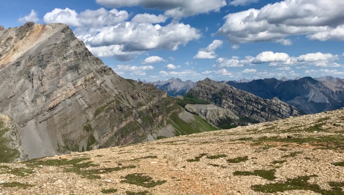
As we came up over a band of rock, we got our first glimpse of one of the hidden gems up in the high alpine environment near Harvey Pass.


Our trail took us through an alpine bowl. Walking by stunted plants and wildflowers that are unique to high alpine environments, and hopping over the little creeks that sustain them, it was a beautiful place to be.


Up on Harvey Pass, we looked out over the Sunshine Meadows (part of a popular ski resort in the winter).  We paused for another tea and cookie break here to rest up for the push to the summit. We had terrific views of Mount Assiniboine (not in this photo), the Matterhorn of our Rockies, and of Mount Temple. Then it was time for the summit push.
  We’d be heading up this scree slope, past many false summits, ultimately getting to the peak that is out of range of this photo. In a sense, we were following along the top of the cliff band that cradled Bourgeau Lake.
We paused for another tea and cookie break here to rest up for the push to the summit. We had terrific views of Mount Assiniboine (not in this photo), the Matterhorn of our Rockies, and of Mount Temple. Then it was time for the summit push. We’d be heading up this scree slope, past many false summits, ultimately getting to the peak that is out of range of this photo. In a sense, we were following along the top of the cliff band that cradled Bourgeau Lake.
Scree is a neat feature, unique to the ramps on mountain peaks: the cracked, broken pieces of a mountain’s back, its rocks can be loose or firm under foot. Scree can be made of small or large rubble, but usually the rock is sharp and jagged and has some grip to it as a result. Scree layers can be deep (which actually makes it delightful to come down, cushioning every step) or quite shallow (making it act like ball bearings on the hard rock layer below). The scree of this mountain wasn’t bad at all… it was more hiking than scrambling as it had a firm, boot-worn trail.
But MAN! Was it ever windy! We struggled to push our bodies into the wind and make progress uphill! Look at the way these teeny flowers shake and quiver in the wind. It takes a lot to move them as they’re really short and compact!
Slow and steady, up we went, staying a safe distance from that cliff edge.

It was hard going, mostly due to the wind. Normally, I’d NEVER be wearing a toque and puffy on the way up a scree ramp on a hot (27C) summer’s day! But that wind!

From the shelter of some large rocks, we could get views down to Bourgeau Lake F–A–R below! Coming up that ramp, we really were hiking along the top of what had felt like cliffs hemming in that lake, the scene of our first tea break of the day.

We passed cornices of snow, stubbornly clinging to the edge of the cliff, even in the heat of early August.

Finally we were at the summit! While its views were amazing, it was disappointingly large, so we missed that feeling of being perched on a peak. There was even a weather station up there… a cubicle, lots of equipment and even a propane tank! So that took away a bit from the “Wow, we made it here!” sense of a peak. However, turning our backs on the equipment and the wind, those views sustained us!

We poked around for a bit, looking at the peaks and watching the steady movement of the clouds across the huge horizon. Some of the underbellies of the clouds were getting dark. We didn’t want to get caught up there in bad weather (especially given that someone had been struck by lightning up there this week!), so we decided to head back down to a safer place and have our lunch.
Heading back down the backside of that mountain, we stayed in the views for a long time. The play of light and shadow, with the way the winds whipped the clouds along, made for such an interesting backdrop.
Safely nestled below Harvey Pass, we sat, looking down over Harvey Lake and finally had our lunch. man, were we ever hungry!

A few drops began coming down from the sky, so we put on raincoats and headed back down into the safety of the forest below, passing through the little creeklets…
… down the last scree slope of the day and past Bourgeau Lake.

On the way down through the forest, we caught views back up of where we’d been. Now we see why we kept getting a sense of false summits! Look at the bumps along the top of the cliff where we were!

I was getting tired by the time we reached the waterfall on the way down and had to watch my footing as I crossed here. But tired as I was, I wouldn’t have traded this adventure for anything!
Mount Bourgeau lies just west of the Banff townsite in Banff National Park, with its trailhead a small parking lot on the side of the Trans Canada Highway.
Stats: 22.8 km return to and from Bourgeau summit; 15km return to and from Bourgeau Lake; 18.5km return to and from Harvey Pass; elevation gain: 1500m
One word of caution: You read in this blog post about how we waited to do lunch until we were down the mountain. There were no thundershowers in the forecast, and yet they can develop. This is the mountains! Weather changes quickly. Forecasts can be very inaccurate. We have a saying here, “If you don’t like the weather, wait 5 minutes.”
A few days before we did this hike, someone was struck by lightening on Mount Bourgeau. When you see bad weather looming, stop! Don’t continue your summit push or ridgeline romp. Get down to the safety of the treelike to wait it out. And if you feel your hair begin to stand on end, get anything metal (poles, inner backpack frames, thermoses, bear spray bottles, etc.) off your body a.s.a.p., then crouch, hug your knees and get on the balls of your feet. For more info on lightening, go to the Government of Canada site.
No comments:
Post a Comment