One feature request I get fairly often is a better printable roads layer, primarily from SARTopo users for use in both urban searches and disaster response. The USGS layer is out of date, MapBuilder doesn't show enough street names, and OpenStreetMap gets shrunk to the point of illegibility when printing. I've always assumed that the proper answer was to bring the default OpenStreetMap style into the MapBuilder rendering stack, which would allow scaling it to match a PDF's resolution - but because that introduced a number of complications, I kept kicking the can down the road.
Necessity is the mother of invention, and a little over a week ago I was called to the Camp Fire in my role as a SAR team member and found myself needing to generate a lot of street maps. One requirement was that they display as many street names as possible, so that responders from around the state could use them for navigation despite not being familiar with the area or having a cell signal. A clean white background was also important to allow marking up maps in the field. Fortunately I'd just wrapped up a MapBuilder import and had a second rendering server sitting idle with the new database, so I was able to hack together a new layer style quicker than expected.
There are a lot of lessons learned from trying to apply my wilderness SAR background to an urban disaster, but one of those is that the new roads layer is here to stay, and I'm sorry I didn't have one out sooner. It will probably get tweaked further and eventually added as a primary layer, but for now it's only available as a custom MapBuilder layer (pro level account or higher required):
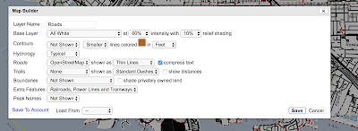 |
| Check "compress text". Recommend setting roads to "thin lines". |
With the "compress text" box checked, a number of changes are made to support showing as many street names as possible:
- Suffixes are dropped (drive, road, street, etc)
- Font size for road labels is reduced
- Labels are allowed to bend more
- Labels are spaced closer together
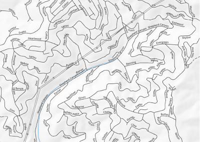 |
| The Oakland hills with most streets labeled at a1:12k scale |
The result isn't exactly pretty compared to something like Google Maps, but it's fairly effective as a first response tool since it will show a lot of street names at usable map scales like 12-24k.
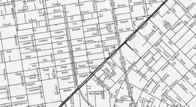 |
| San Francisco at 1:12k |
 |
| Even at 1:24k, a lot of Berkeley street names still get shown |
The layer didn't exist 10 days ago, and hasn't seen a lot of careful development or evaluation, so feedback and suggestions are definitely welcome.


No comments:
Post a Comment